

Chris Robitaille Maps
About the Maps and their Illustrator
Go to these Maps Store Page
Made by the same illustrator of our Blue Rhino Maps, Chris Robitaille. His vintage representation of the printed African destinations are often claimed to become a great display piece on one's wall in their home. They start an easy conversation with family and friends about the fun times you had, the things you saw, and the people you met in your journey inside the homeland of Africa.
It all began back in 1997 shortly after Chris Robitaille had moved from Toronto to Kenya to pursue his first love of painting landscapes and wildlife.
Coincidentally, while living in Kenya, Chris was approached by a good friend and former classmate from the Ontario College of Art in Toronto to see if he was interested in illustrating an antiquarian styled map of Kenya. Chris's friend and his business partner at the time (the original founders of Blue Rhino), wanted to create unique artwork that could be printed on a variety of products and sold in upscale gift shops at Safari Lodges and Resorts throughout the country. At the time, Nairobi, Kenya had a large European expatriate community and the look of these ‘colonial’ maps made them an instant hit.
Shortly thereafter and based on the exciting response from tourists, Blue Rhino commissioned Chris to illustrate these "old-world" style maps for an additional eight African countries which became available throughout most of these countries.
Each of the maps begin with multiple pencil sketches working on the design, content and layout of the map artwork
The medium used to illustrate these maps is pen & ink; more than a half-dozen different pens are used for different map aspects. Afterward, multiple layers of watercolor washes are applied.
Every line, letter and icon is rendered entirely by hand on each new map drawn. The entire process typically takes 5-8 weeks depending on complexity and detail required.
The end result is an entirely custom, unique and original piece of art that has been fully vetted for educational merit, historical and geographic accuracy and cultural relevance.
The maps you see here are not carried or sold by Blue Rhino in Kenya. They are new to True African Art and we bought them direct from the artist to resell.
To see more maps we carry that Chris illustrated and are printed by Blue Rhino, go to the Blue Rhino Maps Store Page.

Map Print of Zanzibar Island, Tanzania
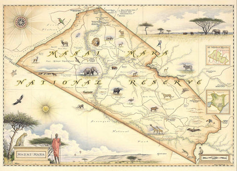
Map Print of Masai Mara